


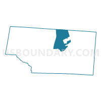
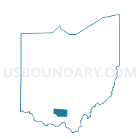
PRECINCT PEE PEE TOWNSHIP, Pike County, Ohio
About
Outline

Summary
| Unique Area Identifier | 651012 |
| Name | PRECINCT PEE PEE TOWNSHIP |
| County | Pike County |
| State | Ohio |
| Area (square miles) | 28.30 |
| Land Area (square miles) | 27.63 |
| Water Area (square miles) | 0.67 |
| % of Land Area | 97.62 |
| % of Water Area | 2.38 |
| Latitude of the Internal Point | 39.11944950 |
| Longtitude of the Internal Point | -83.01572310 |
Maps

Graphs
Select a template below for downloading or customizing gragh for PRECINCT PEE PEE TOWNSHIP, Pike County, Ohio


Neighbors
Neighoring Voting District (by Name) Neighboring Voting District on the Map
- FRANKLIN SOUTH Voting District, Ross County, OH
- HUNTINGTON SOUTH Voting District, Ross County, OH
- PRECINCT NEWTON TOWNSHIP, Pike County, OH
- PRECINCT PEBBLE TOWNSHIP, Pike County, OH
- PRECINCT PIKETON VILLAGE, Pike County, OH
- PRECINCT SEAL TOWNSHIP, Pike County, OH
- PRECINCT WARD 1, Pike County, OH
- PRECINCT WARD 2B, Pike County, OH
- PRECINCT WARD 4, Pike County, OH
- PRECINCT WARD 5, Pike County, OH
- PRECINCT WEST JACKSON TOWNSHIP, Pike County, OH
Top 10 Neighboring County Subdivision (by Population) Neighboring County Subdivision on the Map
- Pee Pee township, Pike County, OH (7,886)
- Huntington township, Ross County, OH (6,220)
- Seal township, Pike County, OH (3,396)
- Pebble township, Pike County, OH (2,553)
- Newton township, Pike County, OH (1,958)
- Franklin township, Ross County, OH (1,705)
- Jackson township, Pike County, OH (1,209)
Top 10 Neighboring Place (by Population) Neighboring Place on the Map
Top 10 Neighboring Unified School District (by Population) Neighboring Unified School District on the Map
- Waverly City School District, OH (11,766)
- Scioto Valley Local School District, OH (8,721)
- Huntington Local School District, OH (6,231)
Top 10 Neighboring State Legislative District Lower Chamber (by Population) Neighboring State Legislative District Lower Chamber on the Map
- State House District 85, OH (125,655)
- State House District 87, OH (120,818)
- State House District 86, OH (114,338)
Top 10 Neighboring State Legislative District Upper Chamber (by Population) Neighboring State Legislative District Upper Chamber on the Map
Top 10 Neighboring 111th Congressional District (by Population) Neighboring 111th Congressional District on the Map
Top 10 Neighboring Census Tract (by Population) Neighboring Census Tract on the Map
- Census Tract 9568, Ross County, OH (6,089)
- Census Tract 9526, Pike County, OH (5,918)
- Census Tract 9523, Pike County, OH (5,497)
- Census Tract 9525, Pike County, OH (3,744)
- Census Tract 9524, Pike County, OH (3,330)